
For more than thirty years, there have been legal safeguards put in place by the British government and the EU to protect – amongst other wildlife - birds, their eggs and their habitats. These protections exist to make sure that they are kept safe from harm or disturbance – regardless of where they have chosen to nest.
Typically, these acts cater to more domestic circumstances; such as nesting birds found in the roof of a family home or the storage room of an office building.
However, in some instances, they implicate more heavy-duty structures – in our case: Offshore platforms.
Due to the skeletal nature of the structures and lack of surrounding alternatives in amongst the wider ocean, it’s of no surprise that offshore platforms have become a popular destination for birds looking to nest.
For the most part, these birds live happily within the iron branches, occasionally swooping towards water for a spot of ocean-borne lunch. They are of no consequence to the platform and the platform is of no consequence to them.
That is, until, the platform needs to be decommissioned.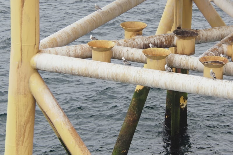
The Job at Hand
While operators are clear in their duty not to harm or endanger the lives of birds, decommissioning cannot begin to take place without a clear and complete understanding of which parts of their platform are home to birds and how many live there exactly.
This issue becomes considerably more problematic as the traditional methods by which these facts were obtained are revealed to be fundamentally flawed for the job.
In times gone by, an ornithologist would need to approach the platform by boat with binoculars in hand and look for birds themselves. Not only was this approach manual and time-consuming, it was literally impossible to confidently survey the topside of the structure.
The Answer: Drones
Cyberhawk has first-hand experience completing an entire nesting bird survey of a wellhead offshore platform. During this expedition, we surveyed the entirety of the structure, including its 1,400 tonne topside and 5 platform wells.
We were able to determine with absolute certainty which parts of the structure housed birds – all from a considerable distance so as not to disturb them or their nests.
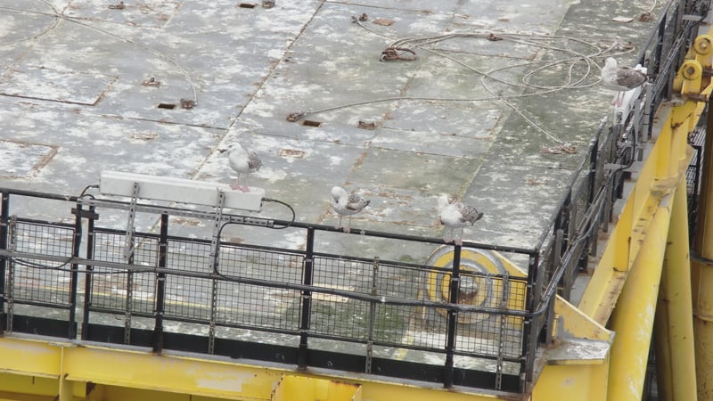
Image taken of the topside of the platform from 50m.
THE CHALLENGE
There has been advice from environmental conservation bodies recommending against the usage of UAVs, a lot of which is on the basis of limited documentation supporting the method.
While prudent to err on the side of caution, to halt progress searching for safer and more effective methods due to a lack of empirical data would be counter-productive to the efforts of environmental conservation.
It is a fundamental part of Cyberhawk - as the global leader in safe drone operation - that we operate with care for the environment.
For instance, the bird nesting calendar and bird regulation awareness are integral parts of our pilot training. Moreover, our operating procedure also prohibits nest disturbance, so much so, that we regularly have to stop a job when inspecting transmission towers in the countryside.
We welcome private and governmental bodies alike in developing guidelines that are conducive to effective bird protection and promote good practice in commercial drone operations in sensitive, protected environments.
While operating offshore, we believe that in sharing our experience developing surveyal methodology with input from seabird ornithologists, the benefit we reap is twofold: We reduce emissions by decreasing boat run times, and complete the job confident in our outcome.
To this day, some organizations still recommend surveying from a nearby boat with binoculars in hand - where the surveyor's view is limited only up to the cellar deck level, leaving out other possible nesting areas, especially from the weather deck and above.
That's why we developed our surveyal system that not only captures every angle of the platform, but makes the birds' safety our priority.
How We Do It
Cyberhawk use a systematic approach whereby we circle the platform completely at an initial distance of 100m while looking for evidence of wildlife via 4k video footage shot from an accompanying camera on the drone. This would be done at varying heights to enable complete coverage of the installation. If, after that, we see no evidence of wildlife, we move 50% closer to the structure and repeat the process. The purpose of this system is to try to remove unnecessary disturbance to any potential birds by keeping noise and presence to a minimum. If no birds were found a second time, the process would be completed once more at 25m from the structure to absolutely conclude whether or not wildlife is present on the platform.
If at any point during the process, any evidence of birds should become apparent, the drone would not move any closer to the structure so as not to disturb them and any imagery would be passed on to an ornithologist.
Case Studies
Because the issue of nesting birds in inopportune places has existed long before now – there is research that exists in relation to drone-based surveyal. Below we have two such studies that promote the use of drones within the field.
In 2017, Sardà-Palomera et al. used a drone to monitor the temporal and spatial dynamics of a black-headed gull colony throughout the breeding period. Detailed information about nesting success and how it relates to distance to the nearest incubating neighbor, as well as distance to the colony boundary, was obtained. For this study, a light commercial UAV was used and flown in several overflights. They found that there were no adverse behaviors from Gulls against the UAV were observed.
Again in 2017, Díaz-Delgado et al. estimated the colony size of slender-billed gull (Chroicocephalus genei) in Doñana National Park, Spain. A number of black-headed gull (Chroicocephalus ridibundus) were also identified. A UAV was used to compare automatic versus manual approaches to counting nests and therefore estimating the number of breeding pairs present during the breeding season. Two UAVs were used for the study. The UAV base station was located 500 m away from the colony and all take-offs and landings took place there. Drone altitudes were 48 m, 50 m, 51 m, and 80 m. There were no signs of disturbance at the Slender-billed gull colony during any drone flight, which suggests that the methodology used was appropriate for colony monitoring.
For more information
If you would like to learn more about our survey options, look here.