
Overview:
Today we look at how data visualization can help reduce project costs and increase productivity in the energy and construction sectors.
A recent study from Accenture reported that almost two-thirds of large construction projects valued at $1B+ exceed their budgets and schedules by between 35% and 50%.
Such figures underline why it is essential to create and maintain organization-wide visibility on all planned construction activities to ensure that potential clashes can be highlighted and avoided.
With this in mind, we look at a major construction project we supported in the energy and capital projects sectors, and consider how the use of drone data collection and drone data processing via our visualization software, iHawk, helped to dramatically improve decision-making, avoid potential clashing and increase productivity (i.e. “more time on tools”).
Putting data at the heart of decision making
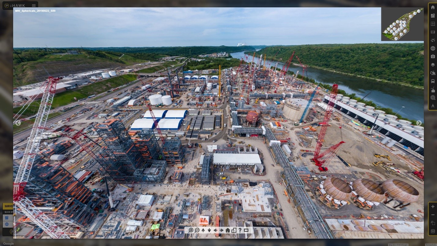
In June 2016, Shell Chemical Appalachia LLC (“Shell”) commenced work on a major petrochemicals plant near Pittsburgh, Pennsylvania, USA. At its peak, construction activity saw up to 7,500 workers on-site per day, including more than 30 contracting companies.
Due to the intense level of construction activity, careful planning and constant information sharing were critical. The project team recognized that they needed a digital approach to manage the flow of information across the site, to allow for informed decisions, develop and adjust execution plans, stay on top of progress and costs, ensure quality, and above all, keep their people safe.
In 2017, Shell selected iHawk, Cyberhawk’s cloud-based, IoT-enabled visualization platform as the foundation tool for managing the construction site. Prior to this, much of the visual information gathered by the site’s ground inspectors had been shared via email or as offline hard copies, which not only limited the usefulness and accessibility of the information, it also meant that much of the information was being lost at shift change or once filed for storing.
The two companies started to collaborate to develop a set of unique, differentiating capabilities to meet a wide range of challenges that the project team was facing.
For Shell’s project team, and, as with any major construction project, iHawk offered these key benefits:
- A single source of the truth
iHawk enabled a community of 700 active users from Shell and 40+ execution contractors to work off the same baseline – in the office, out in the field, and on mobile devices.
So far, 45 interactive, touch-enabled screens have been deployed around the construction and in the operation team’s offices, in meeting rooms and collaboration areas.
This meant that everyone on the team had direct, on the spot access to the iHawk portal. The easily accessible smart screens foster collaboration and teamwork.
iHawk also offered Shell emergency response and egress planning. This meant that the location of every muster point, fire extinguisher, first-aid kit, defibrillator, and other life-saving equipment was marked in the portal for the ease of planning, maintenance, and communication across the site.
If you’re interested in finding out how iHawk can support your project
download your free capital projects capabilities overview pack now!

- Complete data visualization
iHawk not only visualizes drone data, but it also integrates this with imagery from ground inspections, new and existing IoT, and with data from multiple third-party APIs such as flood assessment, equipment tracking, RFID tags, and more into a single visual interface accessible via one single IT platform.
On this particular project, an additional module was developed called ‘Real Estate Management’ in response to the needs of the main EPC contractor managing the site. The joint owner and EPC project management team relied on the high-resolution GIS data, developed from drone imagery, and enriched with layers of contextualized information, in order to plan heavy equipment moves and oversized deliveries, organize equipment staging, and to manage congested laydown area space across the busy 380-acre construction site.
Historically difficult to manage offline with Gannt charts, space planning clashes and constraints can be instantly detected and resolved in a visual domain. The ability to assign a physical area for a specific task and purpose, assign a responsible individual, and publish this information to the stakeholders, is crucial. Not only does iHawk process hundreds of real estate assignments, and add them to a timeline, making them visible to everyone on the team, it helps to drive personal accountability for the success of every task.
- Near real-time equipment & material tracking
On this project, and many others that we have supported, iHawk combined visual data gathered by the UAVs (drones), ground 360 cameras with data from a myriad of field sensors and IoT devices enabling real-time equipment location tracking and performance monitoring.
This meant construction materials could be located across five laydown areas using RFID technology, and more into a single visual interface for the site planners, contractors, and executives.
Visual data management is not limited to drone imagery. Site inspection imagery, for example, taken in large volumes by quality inspectors and construction engineers, is notoriously difficult to gather, catalog, and manage centrally. On this project, Shell and Cyberhawk developed a simple self-service workflow for this kind of content to be captured, uploaded, and linked to an equipment tag. The images can then be instantly shared across the project team, for example, to report the need for remediation action.
This not only helped to identify any potential construction clashes, but it also meant the project team could track the position and usage of all critical equipment. For example, the dozens of cranes deployed across the site were individually tracked using sensors that reported uptime and other telemetry data, which all fed into iHawk via its wireless telematics module and were presented as a data layer on the site map.
By having this information to hand, the project teams could clearly see which cranes were being used at an optimal level and which were not, resulting in huge time and cost savings.
Powerful project results
For construction site owners and operators, any delays or ‘clashes’ on the project mean contractor fees soar, assets are underutilized or sit idle, and ultimately, the project overruns with costly results.
So, the question becomes, how can we avoid this?
Enter iHawk, an intuitive digital solution to visual data management. By adopting our visualization software, we have estimated that every hour of the iHawk portal’s usage translates in the equivalent, often even greater, efficiency gains in the field.
As IT director Pennsylvania Chemicals at Shell, put it: “iHawk has enabled a digital revolution…We see iHawk as a tool that offers opportunities for safety improvements through increased efficiency and improved visualization prior to work activities. The data collected throughout the execution phase is a resourceful legacy that will continue to empower the asset operations team for the entire plant-life.”
.png?width=380&name=Capital%20Project%20Brochure%20On%20Page%20(2).png)
If you’re interested in finding out how iHawk can support your project, find out more here.